
Updated 6:18 PM CT Sat Oct 3: Nolo is a major hurricane, a Category 3 with 115 mph winds (CPHC Advisory 53, 4 PM CT), up from a 110 mph Category 2 this morning, and it is expected to cross the International Date Line on Sunday. In the U.S., heavy rain is causing flash flooding on the Gulf Coast: NWS had 6 Flash Flood Warnings as of 6:18 PM CT, including the New Orleans area, and 5 Flood Watches from southeast Louisiana to the Florida Panhandle. Hurricane Rachel weakened to an 80 mph Category 1 (NHC Advisory 27, 4 PM CT) and is forecast to become a tropical storm on Sunday. The next complete advisories on both hurricanes are due at 10 PM CT.
Correction (6:54 PM CT Sun Sep 27): Earlier versions of this article said Polo peaked as a Category 5 on Friday (Advisories 20–21). That left out its first and strongest peak, and we are sorry for the error. NHC public advisories show Polo first reached its peak of 180 mph (Category 5) with a minimum pressure of 892 mb at Advisory 9, 4 PM CT Tuesday, Sept. 22, and reached 180 mph again on Friday at Advisories 20–21. The category graphic and page 4 of the PDF below (in the Sep 27 graphic and PDF; the current graphic and PDF are corrected) still carry the Friday-only wording; this note corrects them.
HailDataHub Weather Report · Saturday, October 3, 2026 · Evening update · Free storm news, no paywall.
Nolo became a major hurricane on Saturday afternoon and is racing west at 17 mph, staying just south of the Northwestern Hawaiian Islands. The Central Pacific Hurricane Center says it could still strengthen through Sunday, to a forecast peak near 130 mph (Category 4), before weakening begins Monday. In the U.S., NOAA’s Weather Prediction Center has a Slight Risk of flash flooding on the central Gulf Coast tonight and Sunday, with Interstate 10 from Biloxi to Mobile Bay the main concern tonight and 5 to 8 inches possible from Mobile to Tallahassee on Sunday. Rachel keeps weakening southwest of Baja California.
Free 10-page evening Weather Report: Hurricane Nolo, Gulf Coast flooding, Hurricane Rachel and Polo’s final advisory, with maps and sources.
Hurricane Nolo: a major hurricane, crossing the date line Sunday
From the Central Pacific Hurricane Center, Advisory 53 (11 AM HST / 4 PM CT Saturday, Oct. 3):
| Max sustained winds | 115 mph (185 km/h), Category 3 major hurricane, up from 110 mph at Intermediate Advisory 51A (7 AM CT). Nolo reached major strength at Intermediate Advisory 52A (1 PM CT). |
|---|---|
| Minimum pressure | 959 mb (28.32 in), down from 964 mb this morning |
| Location | 23.2°N 173.1°W, about 210 mi SSE of Lisianski Island and 220 mi SW of Maro Reef |
| Movement | West at 17 mph, with some more increase in speed over the next few days |
| Watches and warnings | Tropical Storm Warning for the Papahānaumokuākea Marine National Monument from Maro Reef to Lisianski Island |
| Outlook | Fluctuations in intensity are possible, but Nolo could still strengthen through Sunday. Gradual weakening is likely to begin Monday. Nolo should cross the International Date Line by Sunday midday Hawaii time. |

| When (CT) | Position | Max winds | Strength |
|---|---|---|---|
| Sun 1 AM | 23.3°N 175.8°W | 125 mph | Category 3 |
| Sun 1 PM | 23.8°N 179.1°W | 130 mph | Category 4 |
| Mon 1 AM | 24.7°N 177.6°E | 130 mph | Category 4, west of the date line |
| Mon 1 PM | 25.1°N 174.5°E | 125 mph | Category 3 |
Forecast points from CPHC Forecast Advisory 53, converted to CT. The forecast peak was lowered from 140 mph this morning to 130 mph.
- Today: 110 mph at Advisory 51A (7 AM CT) and Advisory 52 (10 AM CT), then 115 mph and 959 mb at Advisories 52A (1 PM CT) and 53 (4 PM CT).
- Surf: large waves will likely flood some low-lying atolls from Maro Reef to Lisianski Island over the next several days.
Flash flooding on the Gulf Coast; river flooding lingers in the Midwest
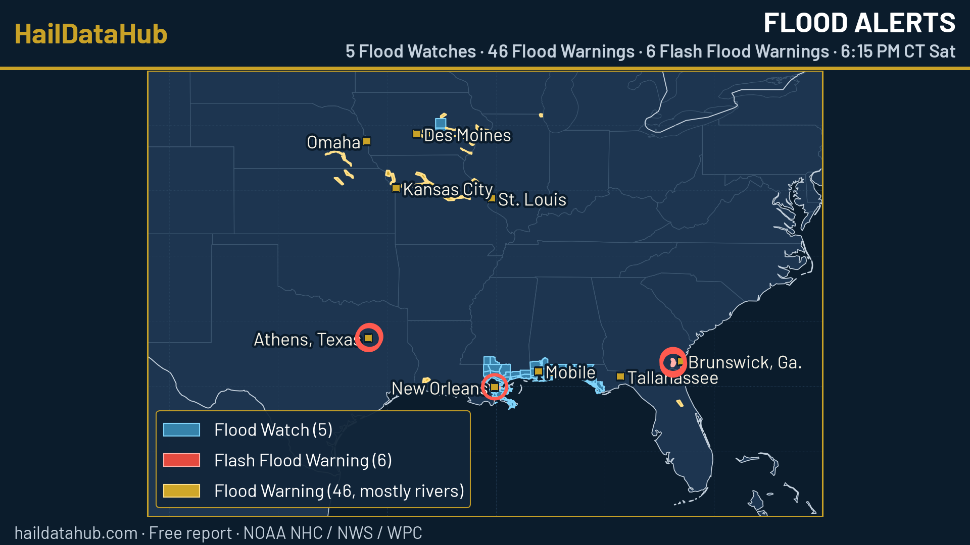
- 6 Flash Flood Warnings as of 6:18 PM CT: the New Orleans area (parts of Jefferson, Orleans, Plaquemines, St. Bernard and St. Charles parishes) until 7:30 PM CT; 2 in Henderson County, Texas, around Athens, where NWS says 6 to 9 inches of rain have fallen, until 9:00 PM CT; 3 in southeast Georgia near Brantley, Camden and Charlton counties, until about 7:15 PM CT.
- 5 NWS Flood Watches in the lower 48: southeast Louisiana including New Orleans, with Pearl River, Pike and Walthall counties in Mississippi; coastal Mississippi; the Mobile and Baldwin County areas of Alabama with the far western Florida Panhandle (all through Sunday evening); and the Florida Panhandle from Walton to Gulf counties (through Monday morning). A river Flood Watch also covers the Iowa River near Tama, Iowa. NWS calls for 4 to 6 more inches in the Mobile area, locally up to 10, and 4 to 7 inches in coastal Mississippi, locally 8 to 10.
- 46 NWS Flood Warnings are in effect, mostly for river flooding. The most are in Missouri 17, Iowa 13, Nebraska 6, Kansas 4, Illinois 3 (one warning can cover more than one state).
- Tonight: WPC has a Slight Risk (level 2 of 4) of flash flooding on the central Gulf Coast, higher-end from southeast Louisiana to the western Florida Panhandle, with locally 4 to 6 inches or more. Slight Risk also on the lower Texas coast and in eastern North Carolina around New Bern.
- Sunday: Slight Risk across the Southeast and the lower Texas coast. The heaviest rain is expected from Mobile to Tallahassee, where 5 to 8 inches are possible, and WPC says an upgrade is possible depending on how much flooding happens tonight.
- Why: WPC points to a weak wave from the Gulf and record or near-record tropical moisture, with a slow cold front to the north.
- Never drive through flooded roads. Check weather.gov for your county.
Hurricane Rachel: weakening, forecast to become a tropical storm Sunday
From NOAA National Hurricane Center Advisory 27 (2 PM MST / 4 PM CT Saturday, Oct. 3):
| Max sustained winds | 80 mph (130 km/h), Category 1, down 10 mph from 90 mph at Advisory 25 (4 AM CT) |
|---|---|
| Minimum pressure | 977 mb (28.85 in) |
| Location | 19.8°N 112.5°W, about 270 mi SW of the southern tip of Baja California |
| Movement | West-northwest at 5 mph; slow tonight, then west to west-northwest and a little faster from Sunday |
| Wind field | Hurricane-force winds out to 45 mi; tropical-storm-force winds out to 150 mi |
| Watches and warnings | No coastal watches or warnings in effect |

| When (CT) | Position | Max winds | Strength |
|---|---|---|---|
| Sun 1 AM | 20.0°N 113.2°W | 75 mph | Category 1 |
| Sun 1 PM | 20.3°N 114.2°W | 70 mph | Tropical storm |
| Mon 1 AM | 20.5°N 115.4°W | 70 mph | Tropical storm |
| Mon 1 PM | 20.6°N 116.8°W | 75 mph | Category 1 |
Forecast points from NHC Forecast Advisory 27, converted to CT.
- Trend: Rachel peaked at 120 mph (Category 3) on Thursday. Today it went from 90 mph (Advisory 25) to 85 mph (Advisory 26, 10 AM CT) and 80 mph (Advisory 27). NHC expects some weakening over the next day, with slight restrengthening possible Monday.
- Surf: swells from Rachel will affect west-central Mexico through the weekend and the Baja California Peninsula through Monday, likely causing life-threatening surf and rip currents.
Hurricane categories explained: Nolo and Rachel now, and Polo’s peak
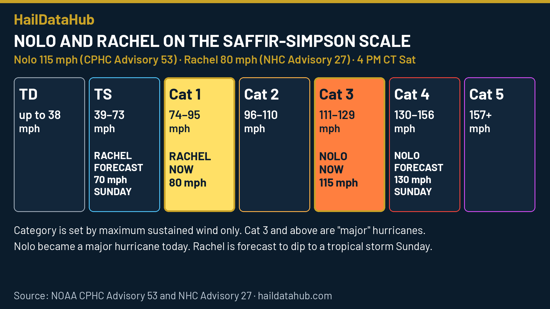
The Saffir-Simpson Hurricane Wind Scale rates hurricanes from 1 to 5 using only the maximum sustained wind (the U.S. 1-minute average). Central pressure, storm surge, rainfall and storm size do not set the category, even though they can be just as deadly. Nolo is officially a Category 3 major hurricane at 115 mph (100 kt) and could reach Category 4 on Sunday. Rachel is a Category 1 at 80 mph (70 kt) and is forecast to drop to a tropical storm (39 to 73 mph) on Sunday. Polo is gone. It peaked as a Category 5 on Friday (Advisories 20–21). It first peaked at 180 mph (Category 5, 892 mb) on Tuesday, Sept. 22 (Advisory 9), and reached 180 mph again on Friday (Advisories 20–21). (Correction)
| Category | Sustained winds | NHC damage summary |
|---|---|---|
| 1 | 74–95 mph (64–82 kt) | Very dangerous winds will produce some damage. Rachel is here now. |
| 2 | 96–110 mph (83–95 kt) | Extremely dangerous winds will cause extensive damage. Nolo was here this morning. |
| 3 (major) | 111–129 mph (96–112 kt) | Devastating damage will occur. Nolo is here now. Rachel peaked here at 120 mph on Thursday. |
| 4 (major) | 130–156 mph (113–136 kt) | Catastrophic damage will occur. Nolo’s forecast peak: 130 mph on Sunday. |
| 5 (major) | 157 mph or higher (137+ kt) | Catastrophic damage will occur |
| “6” (proposed, unofficial) | Over 192 mph (over 167 kt) | A hypothetical category suggested in a 2024 PNAS study. Not used by NHC. |
Is there a Category 6 or 7? Not officially. Category 5 is the top of the official scale and is open-ended. A 2024 study in the Proceedings of the National Academy of Sciences suggested a hypothetical Category 6 for winds above 192 mph. NHC has not adopted it, and Polo never reached that proposed line.
Sources for this section: CPHC Nolo Advisory 53 · CPHC Nolo Forecast Advisory · NHC Rachel Advisory 27 · NHC advisory archive for Polo · NHC Saffir-Simpson scale · PNAS 2024 study
Polo: landfall near Guaymas, then dissipated
Polo made landfall on the Sonora coast a little east of Guaymas, Mexico, on Tuesday, Sept. 29, as a Category 1 hurricane with 75 mph winds, and weakened quickly over the mountains of northwestern Mexico. It was a tropical storm by Tuesday afternoon. NHC’s final advisory (Advisory 38, 8 PM MST / 10 PM CT Tuesday) placed the remnants of Polo near 30.5°N 108.0°W, about 245 miles northeast of Guaymas, with 35 mph winds and a pressure of 996 mb, moving northeast at 23 mph. NHC said Polo had dissipated over northwestern Mexico, and it no longer appears among NHC’s active storms.
Earlier, Polo peaked at 180 mph, a Category 5, in the eastern Pacific: first on Tuesday, Sept. 22 (Advisory 9, when its pressure bottomed out at 892 mb), and again on Friday, Sept. 25 (Advisories 20 and 21, at 900 and 913 mb). See the correction note above and our Polo history slides for the full timeline.
East Coast nor’easter: winding down
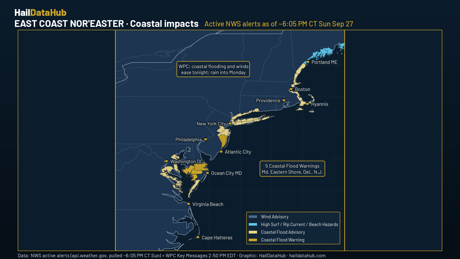
The nor’easter that brought coastal flooding from the Mid-Atlantic to New England over the weekend has largely wound down. The map below shows the alerts active on Sunday evening, Sept. 27.
Other tropics
- Eastern Pacific: NHC gives an area expected to form south of southern Mexico late this weekend or early next week an 80% chance of becoming a tropical depression within seven days (near 0% in the next 48 hours).
- Atlantic: NHC expects no tropical development in the next seven days.
Full details, maps and every source are in the free 10-page evening Weather Report (PDF).
Follow the History: see Hurricane Polo’s week day by day in our Hurricane Polo history slides.
Stay ahead of the next storm
Storm news on HailDataHub is always free. Want free heads-ups when weather heads your way? Get free alerts at haildatahub.com/alerts.
Sources: CPHC Nolo Advisory · CPHC Nolo Forecast Advisory · NHC Rachel Advisory · NHC Rachel Forecast Advisory · NWS active Flood Watches · NWS active Flood Warnings · NWS active Flash Flood Warnings · WPC Excessive Rainfall Outlook · WPC Excessive Rainfall discussion · NHC Eastern Pacific Tropical Weather Outlook · NHC Atlantic Tropical Weather Outlook · NHC Polo Advisory 9 · NHC Polo final advisory · NHC Current Storms. Maps and graphics are HailDataHub graphics drawn from official NOAA data. Not insurance. Not a government forecast. Operated by Meridian Desk for HailDataHub. Terms.