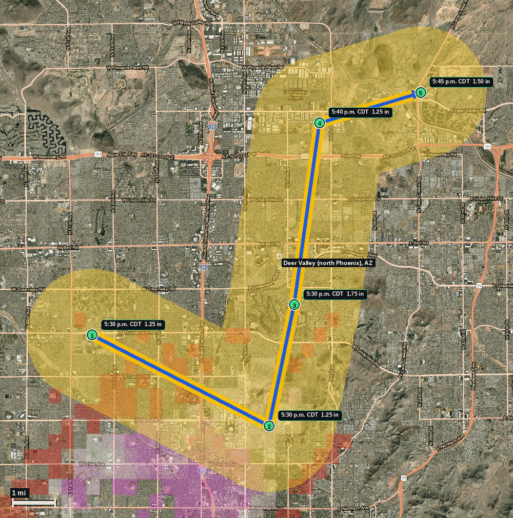
Deer Valley (north Phoenix), AZ: 1.75 in Hail (Maricopa County), Oct 21, 5:30 to 5:45 PM CDT
Report # HDH-AZ-261021-05 · 5:30 p.m. CDT
Live report · October 21, 2026 storm (3:30 to 3:45 PM MST Arizona local). All times Central (CDT).
Population: Phoenix city, AZ, population 1,642,323 (ACS 2024 5-year, place FIPS 0455000); Glendale city, AZ, population 252,833 (ACS 2024 5-year, place FIPS 0427820)
Wednesday, October 21, 2026 · 5 hail reports · max 1.75 in (size comparison: about golf ball) near 4 SSE Deer Valley
Maricopa County, AZ · NWS Phoenix (WFO PSR) · 5:30 p.m. CDT
- 1.25 in (5 SSW Deer Valley) · 5:30 p.m. CDT · 33.61, -112.16 · Live report: 1.25 in (half dollar size), public report, size estimated.
- 1.25 in (6 SSE Deer Valley) · 5:30 p.m. CDT · 33.58, -112.09 · Live report: 1.25 in (half dollar size), public report, size estimated.
- 1.75 in (4 SSE Deer Valley) · 5:30 p.m. CDT · 33.62, -112.08 · Live report: 1.75 in (golf ball size), trained spotter report, size estimated.
- 1.25 in (3 ENE Deer Valley) · 5:40 p.m. CDT · 33.68, -112.07 · Live report: 1.25 in (half dollar size), public report, size estimated.
- 1.50 in (5 ENE Deer Valley) · 5:45 p.m. CDT · 33.69, -112.03 · Live report: 1.50 in (ping pong ball size), trained spotter report, size estimated.
Source: NWS Phoenix Local Storm Reports and SPC Storm Reports (IEM LSR archive).
Severe Thunderstorm Watch 689 (3:35 PM to 11:00 PM CDT, 2035Z to 0400Z) covered all of the hail. All five reports fell inside NWS Phoenix Severe Thunderstorm Warning 145 (5:04 to 5:45 PM CDT). The 5:40 PM report at 3 ENE Deer Valley and the 5:45 PM report at 5 ENE Deer Valley were also inside Severe Thunderstorm Warning 146 (issued 5:40 PM CDT, in effect until 6:30 PM CDT, issued with a hail tag of 2.50 in).
Five reports of 1.25 in or larger to NWS Phoenix in 15 minutes across north Phoenix: one at 1.75 in (golf ball size, trained spotter), one at 1.50 in (ping pong ball size, trained spotter) and three at 1.25 in (half dollar size, public reports). Arizona local time was 3:30 to 3:45 PM MST on Oct 21.
Smaller reports from the same storm are context only (below the 1.25 in threshold): 1.00 in at 4 ENE Peoria and 5 NE Glendale at 5:25 PM CDT, 1.00 in at 3 ESE Deer Valley at 5:40 PM CDT and 0.75 in at 2 ESE Deer Valley at 5:45 PM CDT. A trained spotter also estimated a 60 mph gust at 4 ESE Glendale at 5:30 PM CDT.
Pins run from north central Phoenix (south of Deer Valley) north and east toward the Loop 101 corridor; the blue arrow links the reports in time order (the three 5:30 PM reports are drawn west to east), not a radar track.
Town map