Flagstaff, Arizona Hail Storm October 21, 2026
Report # HDH-AZ-261021-04 · 11:43 a.m. CDT
Live report · October 21, 2026 storm (9:18 to 9:43 AM MST Arizona local). All times Central (CDT).
Population: Flagstaff city, AZ, population 76,445 (ACS 2024 5-year, place FIPS 0423620)
Wednesday, October 21, 2026 · 7 hail reports · max 1.75 in (size comparison: about golf ball) near 2 WSW Downtown Flagstaff
Coconino County, AZ · NWS Flagstaff (WFO FGZ) · 11:43 a.m. CDT
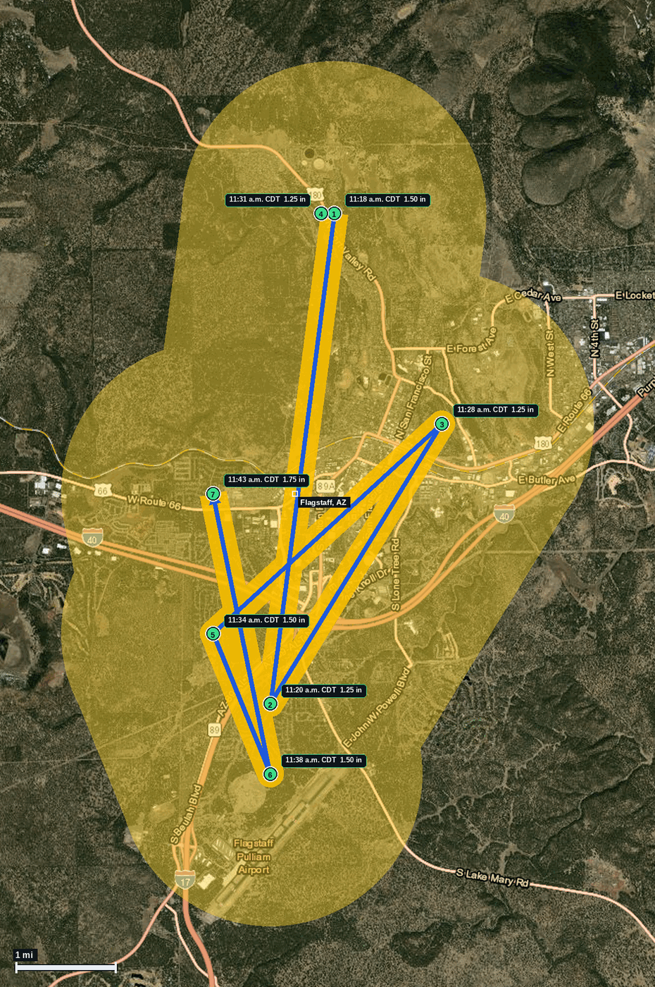
- 1.50 in (2 NW Downtown Flagstaff) · 11:18 a.m. CDT · 35.23, -111.66 · Live report: 1.50 in (ping pong balls), public report; dents observed in a truck.
- 1.25 in (1 N Flagstaff Airport) · 11:20 a.m. CDT · 35.16, -111.67 · Live report: 1.25 in (half dollars), public report, size estimated.
- 1.25 in (1 NE Downtown Flagstaff) · 11:28 a.m. CDT · 35.20, -111.64 · Live report: 1.25 in (half dollars), public report.
- 1.25 in (2 NW Downtown Flagstaff) · 11:31 a.m. CDT · 35.23, -111.66 · Live report: 1.25 in (half dollars), public report; hail accumulation on the ground.
- 1.50 in (2 N Flagstaff Airport) · 11:34 a.m. CDT · 35.17, -111.68 · Live report: 1.50 in (ping pong balls), public report via Facebook, size estimated; time corrected by NWS.
- 1.50 in (1 N Flagstaff Airport) · 11:38 a.m. CDT · 35.15, -111.67 · Live report: 1.50 in (ping pong balls), NWS employee report.
- 1.75 in (2 WSW Downtown Flagstaff) · 11:43 a.m. CDT · 35.19, -111.68 · Live report: 1.75 in (golf balls), public report via Facebook; time corrected by NWS.
Source: NWS Flagstaff Local Storm Reports and SPC Storm Reports (IEM LSR archive).
The first four reports fell inside FGZ Tornado Warning 6 (11:09 to 11:34 AM CDT). The 11:28 and 11:31 reports were also inside Tornado Warning 7 (issued 11:22 AM CDT). The 11:38 AM report at 1 N Flagstaff Airport was outside both warning polygons. The 11:34 AM report at 2 N Flagstaff Airport was inside both the Tornado Warning 6 and Tornado Warning 7 polygons, at the minute Warning 6 expired. The 11:43 AM golf ball report at 2 WSW Downtown Flagstaff was inside Tornado Warning 7 (in effect until 11:45 AM CDT).
Seven reports of 1.25 in or larger to NWS Flagstaff in 25 minutes: one at 1.75 in (golf ball size), three at 1.50 in (ping pong ball size, one with dents seen on a truck), and three at 1.25 in (half dollar size, one with hail covering the ground). Arizona local time was 9:18 to 9:43 AM MST on Oct 21.
NWS Flagstaff corrected the times of the 2 N Flagstaff Airport and 2 WSW Downtown Flagstaff reports to 11:34 and 11:43 AM CDT; each is counted once at the corrected time. A 1.00 in (quarter size) report at 1 N Downtown Flagstaff at 11:28 AM CDT is below the 1.25 in threshold and is context only.
Flagstaff Pulliam Airport ASOS (KFLG) logged a peak wind of 63 kt (72 mph) from 220 degrees at 11:17 AM CDT (16:17Z), per the KFLG 16:18Z special observation (IEM ASOS archive).
Pins run from north of downtown Flagstaff to just north of Flagstaff Pulliam Airport and west-southwest of downtown; the blue arrow links the reports in time order, not a radar track.
Town map