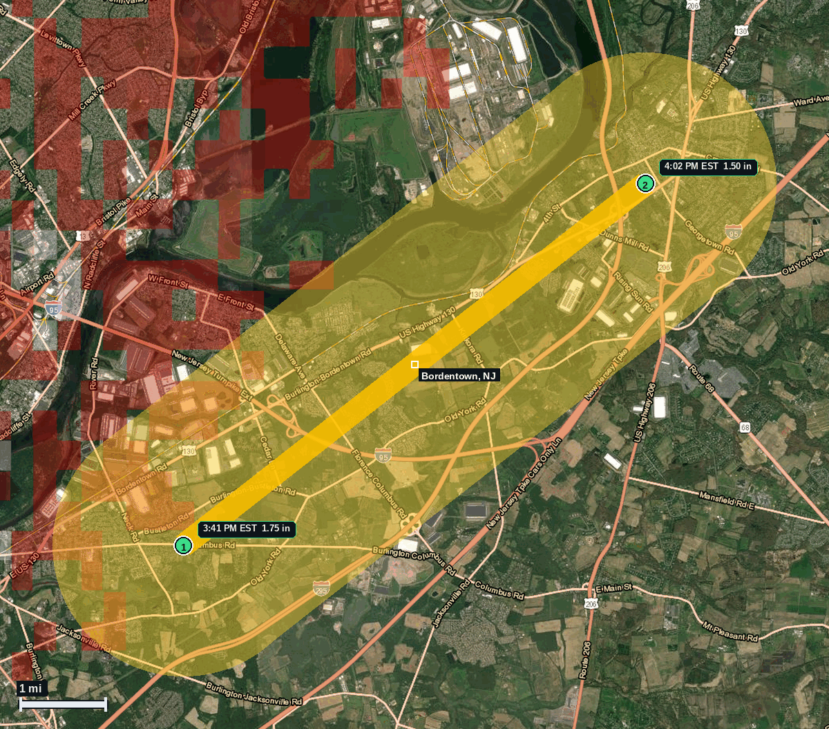
1 NE Burlington Township, NJ: 1.75 in Hail (Burlington County), Nov 12, 3:41 PM EST
Report # HDH-NJ-261112-01 · 3:41 PM EST
Live report · November 12, 2026 storm (largest 3:41 PM EST, 1:41 PM MST; Bordentown 4:02 PM EST, time estimated from radar). All times Eastern (EST), MST shown where noted.
Population: Base Census (not the affected number): Burlington Township, NJ, 24,127; Burlington city, NJ, 9,993; Bordentown city, NJ, 4,026; Bordentown Township, NJ, 12,120 (ACS 2024 5-year). The impact ESTIMATE is the yellow swath, not these full-town counts.
Thursday, November 12, 2026 · 4 hail reports · max 1.75 in (size comparison: about golf ball) near 1 NE Burlington Township
Burlington County, NJ · NWS Mount Holly · 3:41 PM EST
- 1.75 in (1 NE Burlington Township) · 3:41 PM EST · 40.08, -74.81 · Live report: 1.75 in (trained spotter, photo sent to NWS via social media), about golf ball size.
- 1.50 in (Bordentown) · 4:02 PM EST · 40.14, -74.71 · Live report: 1.50 in (trained spotter), about ping pong ball size. Time estimated from radar.
- 1.00 in (1 SE Rancocas) · 3:55 PM EST · 40.00, -74.86 · Live report: 1.00 in (trained spotter; time given in the report).
- 1.00 in (Bordentown) · 4:01 PM EST · 40.15, -74.71 · Live report: 1.00 in (public).
Source: NWS Mount Holly Local Storm Reports, 1.75 in at 1 NE Burlington Township (trained spotter, photo sent to NWS via social media) and 1.50 in at Bordentown (trained spotter; time estimated from radar), and SPC Storm Reports (IEM LSR archive).
The 1.75 in report at 1 NE Burlington Township at 3:41 PM EST fell during an NWS Mount Holly Tornado Warning (in effect until 4:15 PM EST) for north central Burlington County that named Burlington and noted radar indicated rotation, and during a Severe Thunderstorm Warning (in effect until 4:30 PM EST) that named Burlington. Tornado Watch 705 (until 7:00 PM EST) included Burlington County. A Flash Flood Warning covering northwestern Burlington County, which named Burlington, was also in effect (until 7:30 PM EST). The 1.50 in report at Bordentown, with the time estimated from radar at 4:02 PM EST, fell during the same Tornado Warning and Severe Thunderstorm Warning; a Flash Flood Warning naming Bordentown was also in effect by that time (until 8:00 PM EST). No tornado was confirmed at either pin at the time of these hail reports.
Largest hail: 1.75 in (trained spotter, photo sent to NWS via social media), about golf ball size, at 1 NE Burlington Township, Burlington County, at 3:41 PM EST (2041Z, 1:41 PM MST), listed in the NWS Mount Holly Local Storm Report issued at 4:15 PM EST and on IEM storm reports. A second official report of 1.50 in (trained spotter), about ping pong ball size, was listed at Bordentown, Burlington County, at 4:02 PM EST (2102Z, 2:02 PM MST), time estimated from radar, in the NWS Mount Holly Local Storm Report issued at 4:04 PM EST and on SPC and IEM storm reports. Both 1.25 in or larger reports are in the yellow swath, about 6.7 miles apart.
Nearby official reports of 1.00 in were listed 1 SE Rancocas at 3:55 PM EST (trained spotter; time given in the report) and at Bordentown at 4:01 PM EST (public). NWS Mount Holly also listed storm wind damage with wires down 2 S Bordentown Township in Mansfield Township at 4:00 PM EST and 2 SE Bordentown Township in Chesterfield at 4:02 PM EST, both from the emergency manager. Those are wind-damage reports, not a confirmed tornado.
Same storm: about 16 miles west, 1.50 in at 1 S Northampton Township at 3:40 PM EST (report HDH-PA-261112-01): 1 S Northampton Township, PA: 1.50 in Hail (Bucks County).
Town map