
Updated 6:20 PM CT Saturday, Oct 31, 2026: a Halloween night atmospheric river is spreading heavy rain across the Southwest, with a WPC Moderate Risk (level 3 of 4) of flash flooding Sunday for the Four Corners and Utah and Flood Watches into Monday. Flood Warnings are up on the Salt and Verde rivers near Phoenix, flash flooding hit the New Orleans area this evening, and Florida king tides continue.
HailDataHub Weather Report · Saturday evening, October 31, 2026 · No paywall.
New from HailDataHub
The American Weather Almanac, 2026-27 First Edition
Hardcover, $89.99 on Amazon.
Get the Almanac on AmazonLatest report: 6-page Saturday evening Weather Report (Sat Oct 31, 6:20 PM CT). The Southwest atmospheric river and river flooding, Halloween night flash flooding near New Orleans and on Kauai, Florida king tides, mountain snow, Monday’s Plains storm, the tropics, top weather stories, and 41 clickable official sources.
Read the latest Weather Report (PDF)
Earlier reports (archive): Sat Oct 31 morning · Fri Oct 30 evening · Fri Oct 30 morning · Thu Oct 29 morning · Wed Oct 28 evening · Wed Oct 28 morning · Tue Oct 27 evening · Tue Oct 27 morning · Mon Oct 26 evening · Mon Oct 26 morning · Sun Oct 25 evening · Sun Oct 25 morning · Sat Oct 24 evening · Sat Oct 24 morning · Fri Oct 23 evening · Fri Oct 23 morning · Thu Oct 22 evening · Thu Oct 22 morning · Wed Oct 21 morning · Tue Oct 20 morning · Mon Oct 19 morning · Sun Oct 18 evening · Sun Oct 18 morning · Sat Oct 17 evening · Sat Oct 17 morning · Fri Oct 16 evening · Fri Oct 16 morning · Thu Oct 15 evening · Thu Oct 15 morning · Wed Oct 14 evening · Wed Oct 14 morning · Tue Oct 13 evening · Tue Oct 13 morning · Mon Oct 12 morning · Sun Oct 11 morning · Sat Oct 10 evening · Sat Oct 10 morning · Fri Oct 9 evening · Fri Oct 9 morning · Wed Oct 7 evening · Wed Oct 7 late morning · Wed Oct 7 morning · Tue Oct 6 evening · Tue Oct 6 morning
Watch on Facebook (Saturday evening video)
Southwest atmospheric river: flood threat to Monday
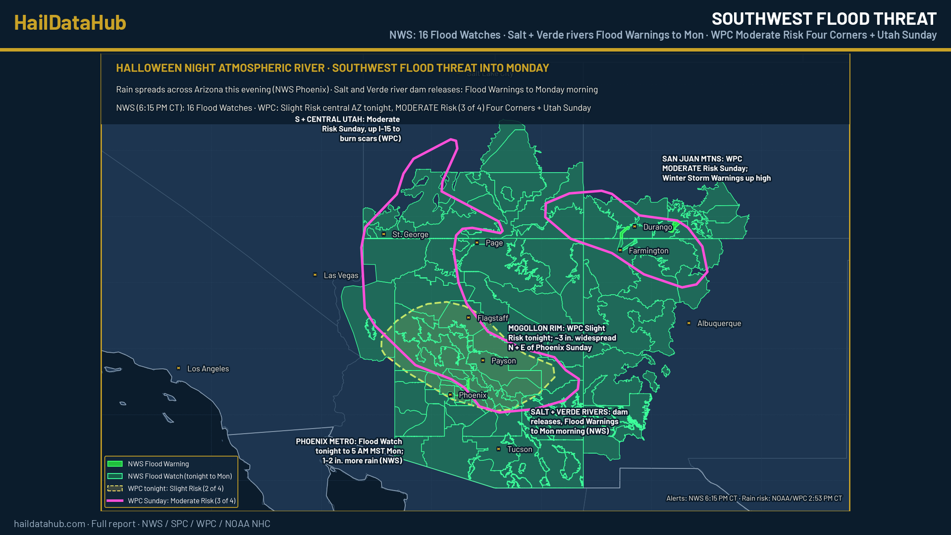
- Tonight (NWS Phoenix): the rain shield spreads northeast this evening, covering much of the area by about 8 to 10 PM CT (7 to 9 PM MST). NWS advised wrapping up trick-or-treating early.
- WPC (2:53 PM CT): tonight, a Slight Risk (level 2 of 4) for central Arizona and the Mogollon Rim; Marginal for much of Nevada, the Sierra foothills, the Southern California mountains and the southern Utah slot canyons.
- Sunday: the Moderate Risk (level 3 of 4) stays in two areas: the San Juan Mountains of southwest Colorado, and the Mogollon Rim north through southern and central Utah up I-15 to burn scars near I-15 and I-70. The Slight Risk reaches the Salt Lake City metro. Moisture runs 4 to 6 standard deviations above normal, with widespread totals near 3 inches north and east of Phoenix and 2 to 4 inches on upslope terrain (WPC); a higher-end Moderate Risk is possible. NWS Phoenix: 1 to 2 inches more for the metro.
- Flood Watches (NWS, 6:15 PM CT): 16 nationwide. NWS Phoenix, Tucson and Flagstaff from tonight (11 PM MST) to 6 AM CT Monday (5 AM MST); NWS Las Vegas (Mohave County, Lake Havasu, Lake Mead, Lincoln County, Nev.) tonight to Monday morning; NWS Salt Lake City all day Sunday (Zion, Bryce, Capitol Reef, Lake Powell, Castle Country); NWS Grand Junction and Albuquerque Sunday to midday Monday; NWS El Paso (Gila region, Silver City) Sunday; NWS Pueblo for the eastern San Juans Sunday and Monday and the San Luis Valley Sunday evening to Wednesday morning.
- Salt River: Flood Warning for floodgate releases from Granite Reef Dam down to the Tempe Marketplace area and its low-water crossings, to 8:45 AM CT Monday (7:45 AM MST).
- Verde River: new Flood Warning for Bartlett Dam releases (Rio Verde, Fort McDowell) to 9 AM CT Monday (8 AM MST).
- San Juan River at Pagosa Springs, Colo. (NWS Grand Junction): major flooding forecast, cresting near 17.0 feet early Monday (flood stage 10.5 feet), approaching the flood of record. La Plata River at Hesperus: minor flooding Sunday evening. NWS Albuquerque Flood Advisories for the Animas and San Juan rivers in San Juan County, N.M., into Tuesday.
Halloween night: New Orleans area, Kauai and the rest of the U.S.
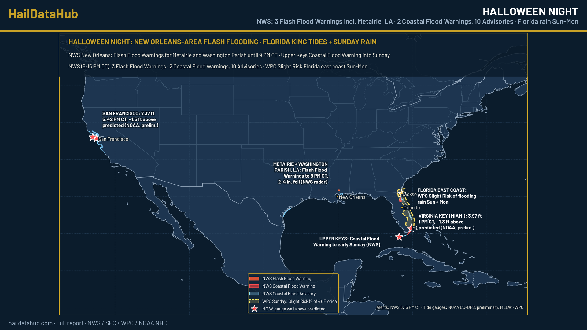
- New Orleans area (NWS New Orleans): Flash Flood Warnings for north-central Jefferson Parish including Metairie (5:57 PM CT; radar estimates 2 to 4 inches had fallen) and east-central Washington Parish (6:05 PM CT; 2 to 3 inches), both to 9 PM CT. Flood Advisory for Metairie, Harahan, River Ridge, Westwego and western Orleans Parish to 7 PM CT. Minor coastal flooding on the southeast Louisiana and Mississippi coast midnight to 9 AM CT Sunday.
- Kauai (NWS Honolulu): Flash Flood Warning for all of Kauai 4:45 to 7:45 PM CT, with rain at 1 to 3 inches per hour and a rapid rise on the Hanalei River gauge.
- Rest of the U.S.: dry in the East under high pressure (WPC). SPC (20Z): no organized severe storms expected through tonight. 3 Flash Flood Warnings nationwide. Clocks fall back at 2 AM Sunday (NIST).
Florida king tides and Sunday to Monday rain
- Alerts (NWS, 6:15 PM CT): 2 Coastal Flood Warnings, 10 Advisories and 5 High Surf Advisories. Upper Keys warning to 4 AM CT Sunday (renewed 3:01 PM CT); eastern Putnam County warning to midnight CT Sunday night; moderate flooding on the St. Johns River near Astor.
- NOAA gauges (preliminary, MLLW): Virginia Key 3.97 feet at 1 PM CT (about 1.3 feet above the predicted 2.68 feet); Key West 2.56 feet at 3:06 PM CT (about 1.2 feet above predicted); San Francisco 7.37 feet at 5:42 PM CT and Point Reyes 7.35 feet at 5:12 PM CT (about 1.5 feet above predicted).
- WPC: Slight Risk of flash flooding on the Florida east coast Sunday (expanded north through Jacksonville) and along the I-95 corridor Monday.
Mountain snow, Monday’s Plains storm and the tropics
- 4 Winter Storm Warnings: Ruby Mountains, Nev. (12 to 16 inches above 7,500 feet through Sunday evening); northwest and southwest San Juans (12 to 18 inches above 10,000 feet, gusts to 45 mph, 7 AM CT Sunday to 1 PM CT Monday); eastern San Juans above 10,000 feet; Skagway, Alaska.
- 9 Winter Weather Advisories: Tahoe, Mono, the Sierra above 5,000 feet, the Yosemite, Sequoia and Kings Canyon high country, Sun Valley, Idaho, the Wasatch south of I-80 and western Uintas, the central Colorado mountains and the Wind River Mountains, Wyo.
- Monday (WPC): a deep low over the central High Plains with gusty winds, possible severe storms in the central and southern Plains, and 2 to 4 inches of rain from eastern South Dakota into central Minnesota.
- Tropics: no NHC storms. Atlantic: no formation expected in 7 days. Well southeast of Hawaii: 40% in 7 days.
Top weather stories
- Southwest atmospheric river arrives (WPC, NWS Phoenix).
- Phoenix-area rivers: Salt and Verde River Flood Warnings (NWS Phoenix).
- New Orleans-area flash flooding (NWS New Orleans).
- Pagosa Springs flood forecast (NWS Grand Junction).
- Florida king tides and rain (NWS, NOAA), and clocks fall back Sunday (NIST).
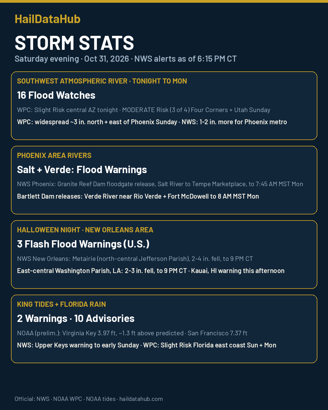
Since this morning (NWS): Flood Watches 12 to 16, Flash Flood Warnings 0 to 3, Flood Warnings 3 to 5, Coastal Flood Advisories 12 to 10, High Surf Advisories 6 to 5, Winter Storm Warnings 1 to 4, Winter Weather Advisories 8 to 9. Earlier this week: 2 S Downtown Las Vegas, NV hail report.
What to do
In the Southwest tonight through Monday, never drive into floodwater or across a flooded wash or low-water crossing; turn around. Stay out of slot canyons and away from burn scars and dry washes, keep clear of the Salt and Verde rivers below the dams, and have a way to get warnings day and night. Near New Orleans and on the Florida coast, avoid flooded streets and move cars out of known flood spots before high tide. Set clocks back one hour before bed.
After hail or flooding, photograph your roof, siding, windows and vehicles from several angles before cleanup, note the date and time, keep receipts, make only temporary repairs, then call your insurer. Flood damage usually needs flood insurance.
Full details, maps and every source are in the latest Weather Report (PDF).
Stay ahead of the next storm
Want a heads-up when weather heads your way? Get hail alerts at haildatahub.com/alerts.
Sources: NWS Phoenix · WPC excessive rainfall · SPC Day 1 outlook · NWS Tucson · NWS Flagstaff · NWS Las Vegas · NWS Salt Lake City · NWS Grand Junction · NWS Albuquerque · NWS El Paso · NWS Pueblo · NWS New Orleans · NWS Honolulu · NOAA Tides and Currents · NWS Key West · NWS Miami · NWS Jacksonville · NWS Elko · NWS Reno · NWS Juneau · NHC · NIST daylight saving time
Follow the History: see the week of Hurricane Polo day by day in our Hurricane Polo history slides.
Correction (6:54 PM CT Sun Sep 27): Earlier versions of this article said Polo peaked as a Category 5 on Friday (Advisories 20 and 21). That left out its first and strongest peak, and we are sorry for the error. NHC public advisories show Polo first reached its peak of 180 mph (Category 5) with a minimum pressure of 892 mb at Advisory 9, 4 PM CT Tuesday, Sept. 22, and reached 180 mph again on Friday at Advisories 20 and 21. The category graphic and page 4 of the PDF below (in the Sep 27 graphic and PDF; the current graphic and PDF are corrected) still carry the Friday-only wording; this note corrects them.